About Laboratory
Our lab is located in the Scientific Research Center, Soran University, and it is a backbone for advancing geospatial research and education in the Kurdistan region This lab will be equipped with state-of-the-art GIS and remote sensing technologies, benefiting research and student education in eastern India by allowing investigation into spatial phenomena as well as generating solutions to the newest global issues. The lab serves as a venue to produce detailed maps, geospatial models, and conduct advanced spatial analyses with a great focus on real-world applications and research excellence. A major part of the lab’s mission is to share data, giving researchers access to credible geospatial datasets across various research projects. The lab bridges the theoretical–practical divide through its collaborative developed and innovative spaces. By equipping researchers and students with the tools they need to tackle regional and global issues — whether it be environmental facilitation, urban region planning, or efficient resource disbursement — the GIS and Remote Sensing Lab plays a vital role in realizing sustainable development.
Our Mission
The GIS and Remote Sensing Lab has been establish to create a well-suited platform for the researchers and students which functionality connects to geospatial science in depth. The lab aims to promote high quality maps and models to meet a range of research needs from tracking environmental changes to informing urban and regional planning decisions. The lab provides expertise in spatial analysis and assists researchers in addressing complex problems like site suitability assessments, resource distribution studies, and land use mapping. Data sharing is a major aspect of the lab, working to ensure researchers have access to dependable geospatial datasets that can increase the quality and scope of their work. Along with research, the lab focuses on capacity building by conducting training and mentorship to students and researchers, enabling them to use GIS and remote sensing tools independently. The lab strives to build a dynamic research community that advances knowledge, offers practical solutions, and supports the sustainable advancement of the Kurdistan region and beyond through fostering interdisciplinary cooperation and interdisciplinary research.
Our Vision
Vision Statement: The GIS and Remote Sensing Lab intends to be recognized as a premier center of excellence in the field of geospatial research and education, serving as a catalyst for positive change through contributions towards the advancement of science, technology, and sustainable development. The lab hopes to provide researchers, students and policy makers with the knowledge and tools to make data-driven decisions. The lab works to tackle some of the greatest challenges of today such as climate change, urban expansion, and natural resource management by fostering innovation and collaboration, whilst making these advanced geospatial technologies available to the wider academic and professional community.
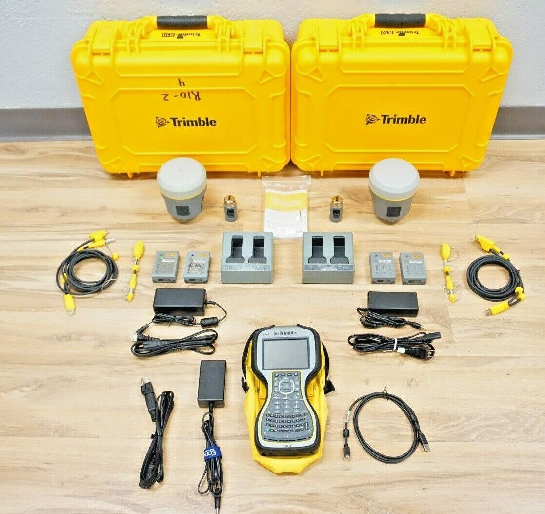
Trimble GPS
Trimble Global Positioning System is the most reliable high precision global positioning system widely used in geospatial applications like land survey, mapping, and spatial analysis. With a well-deserved reputation for accuracy and durability, it leverages hardware and software to provide sub-meter to centimeter precision, making it suitable for both research and professional applications. The system generally comprises receivers, handheld controllers, and antennas, intended to be deployed at multiple field conditions. Trimble has a range of GPS devices and field software that work harmoniously with GIS software when data needs to be collected from the field for the project that requires accurate spatial data.
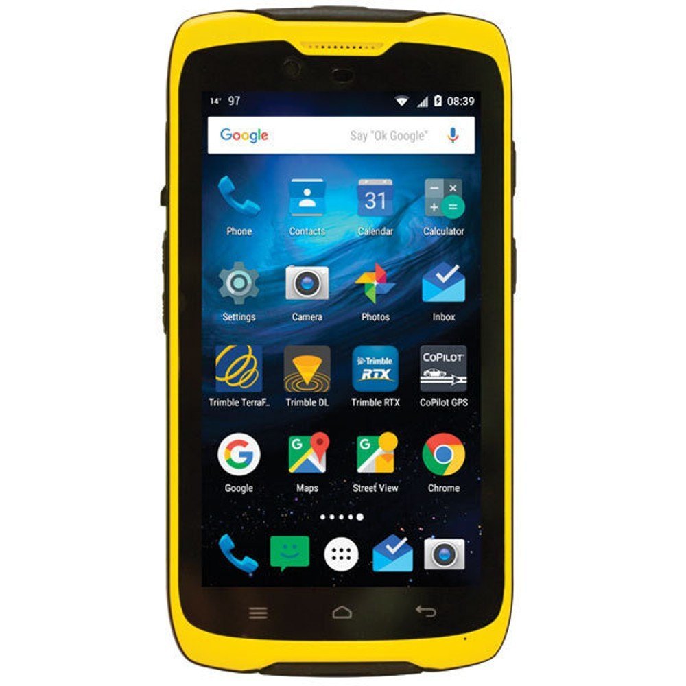
Trimble Handheld GPS System
The Trimble Handheld GPS System description is a small, portable device made for field data collection. With durability and precision at its core, it combines advanced GPS technology with user-friendly features to suit various applications, from land surveying and environmental monitoring to geospatial mapping. With powerful processors and high-resolution touch screens, Trimble handheld devices empower users to capture, store and analyze spatial data quickly and efficiently. With these systems, you are guaranteed to have reliable results in difficult environments with accuracy sub-meter to centimeter level. Researchers and professionals alike can take advantage of this versatility, as the Trimble Handheld GPS System is compatible with GIS and mapping software, allowing for smooth integration into geospatial workflows.

Handheld Soil Tester
The Handheld Soil Tester is an advanced and portable device designed for precise measurement of soil parameters, including temperature, humidity, conductivity, pH, and nutrient levels such as nitrogen, phosphorus, and potassium. With its compact design and ease of use, this tester is ideal for agricultural professionals, researchers, and environmental scientists aiming to optimize soil quality and plant growth. Powered by a universal voltage range of 100V to 240V, the device ensures reliable operation in various settings. Its multi-functional capability provides quick and accurate readings, enabling users to make informed decisions about soil health and fertility. The Handheld Soil Tester is an essential tool for enhancing agricultural productivity, sustainable land use, and scientific soil analysis.
Meet Our Team
Mohammed Mirza Agha Mahmood
Head of laboratory,I work in the GIS Lab, focusing on creating maps, building spatial models, conducting spatial analyses, and sharing geospatial data to support researchers and students in their academic and professional projects.
Publications
Our team has published numerous peer-reviewed articles in high-impact journals. For a full list of publications, visit our website.


Datasets
Explore our datasets on analytical research and case studies. Available for academic and research use.
Contact Us
For inquiries, collaborations, or more information, email us at [email protected].